Map of Puerto Rico: Location, Cities, Beaches & Facts
Puerto Rico holds the easternmost position among the Greater Antilles, sitting about 50 miles east of the Dominican Republic in the northeastern Caribbean—roughly 1,000 miles southeast of Florida. Knowing where things are can make the difference between a smooth visit and a wrong turn into unfamiliar territory.
Status: Unincorporated U.S. territory · Location: Caribbean Sea, east of Dominican Republic · Citizenship: Puerto Ricans are U.S. citizens · Currency: U.S. dollar · Primary Crime Issue: Drug-related crime
Quick snapshot
- Unincorporated U.S. territory since 1898 (Welcome to Puerto Rico)
- U.S. citizenship granted in 1917 (Britannica)
- Hurricane season runs June 1 – November 30 (Christie’s Real Estate Puerto Rico)
- Current safety variations by specific neighborhood
- Updated crime statistics by municipality
- Exact visitor numbers for lesser-known beaches
- Old San Juan founded in 1521 by Spanish settlers
- U.S. sovereignty established in 1898
- Citizenship granted in 1917
- Continued tourism growth in safe resort areas
- Ongoing infrastructure improvements post-hurricane
- Growing popularity of Rincón surfing destination
| Field | Value |
|---|---|
| Official Name | Commonwealth of Puerto Rico |
| Capital | San Juan |
| Area | 3,515 sq mi |
| Population | 3.2 million |
| Language | Spanish and English |
| Hurricane Season | June 1 – November 30 |
Where is Puerto Rico located?
Puerto Rico sits in the northeastern Caribbean, positioned roughly 1,000 miles southeast of Florida. On any world map or Caribbean chart, you’ll find it roughly 50 miles east of the Dominican Republic and about 75 miles west of the U.S. Virgin Islands. Its coordinates place it between roughly 17°50′ and 18°30′ North latitude.
Puerto Rico on world and Caribbean maps
A map of Puerto Rico typically shows a roughly rectangular main island measuring about 100 miles long and 35 miles wide. The island is the easternmost and smallest of the Greater Antilles—a chain that also includes Cuba, Hispaniola (Haiti and the Dominican Republic), and Jamaica. This placement puts Puerto Rico squarely between North and South America, making it a natural stopping point for centuries of maritime traffic.
Several smaller islands surround the main landmass. Vieques and Culebra, two islands about 20 miles east of the main island, are part of Puerto Rico’s municipality and feature some of the most acclaimed beaches in the Caribbean. The Mona Passage separates Puerto Rico from the Dominican Republic to the west, while the Anegada Passage separates it from the Virgin Islands to the east.
Surrounding islands and key landmarks
The surrounding islands fall into two categories: the main municipality islands and outlying cays. Vieques and Culebra serve as the most popular additions to any Puerto Rico itinerary. Vieques hosts a famous bioluminescent bay, while Culebra draws snorkelers to its protected waters and coral reefs.
- Vieques – Located 20 miles east of the main island, known for Mosquito Bay bioluminescence
- Culebra – East of Vieques, home to Flamenco Beach, consistently rated among the Caribbean’s best
- Mona – Small island west of Puerto Rico, important bird sanctuary
- Culebrita – Tiny islet near Culebra with snorkeling and beach access
What country does Puerto Rico belong to?
Puerto Rico is an unincorporated territory of the United States—not an independent country. This status means Puerto Rico is subject to U.S. sovereignty but operates under its own local constitution, established by the Puerto Rican Federal Relations Agency. The island has no voting representation in Congress and cannot participate in U.S. presidential elections.
U.S. territory status
The United States acquired Puerto Rico in 1898 following the Spanish-American War, when Spain ceded the island under the Treaty of Paris. Congress then established the current territorial framework through the Foraker Act of 1900 and later the Puerto Rico Federal Relations Act. This arrangement grants Puerto Rico internal self-government while keeping defense and foreign policy under U.S. jurisdiction.
As a U.S. territory, Puerto Rico receives certain federal funding and programs, though some benefits available to U.S. states do not automatically apply. The IRS notes that Puerto Rico operates under its own tax incentive programs—Sections 20 and 22 of the Internal Revenue Code—which offer unique benefits not found in any U.S. state.
Not an independent country
Despite its distinct culture, language, and history, Puerto Rico remains a U.S. territory. The island has considered status changes several times, including referenda on statehood, independence, or enhanced autonomy, but no change has been enacted. The Britannica encyclopedia documents that Puerto Ricans have held U.S. citizenship since 1917, when the Jones Act conferred citizenship on all territorial residents.
Travelers from the United States need no passport to visit Puerto Rico—just government-issued ID. This makes Puerto Rico one of the easiest international destinations for U.S. citizens to reach.
What this means: whether you’re planning a vacation or considering relocation, the territory status directly affects travel documentation, tax obligations, and federal program eligibility.
Are Puerto Ricans U.S. citizens?
Yes. Puerto Ricans are U.S. citizens by birth, a status that carries significant practical implications. Since 1917, every person born in Puerto Rico automatically receives U.S. citizenship at birth—without needing to go through naturalization processes that apply to most other territories and countries.
Citizenship rights and history
The Jones-Shafroth Act of 1917 granted U.S. citizenship to all Puerto Rican residents. This legislation transformed legal status for island residents while maintaining Puerto Rico’s territorial government structure. Since then, Puerto Rican citizens have held the right to travel freely to and from the United States, work in any U.S. jurisdiction without restrictions, and receive Social Security and Medicare benefits.
Puerto Ricans serving in the U.S. military have fought in every major conflict since World War I, and notably, Puerto Rican soldiers have achieved distinguished records in Vietnam, Korea, and Middle East operations. The Britannica encyclopedia notes this citizenship link shaped Puerto Rico’s relationship with the mainland United States throughout the 20th century.
U.S. passports issued to Puerto Rican citizens list the place of birth as “Puerto Rico, United States”—reflecting the territory’s unique constitutional status. This designation matters for international travel, as some countries treat Puerto Rican passport holders differently than those from U.S. states.
Puerto Ricans cannot vote in U.S. presidential elections and have no voting representation in Congress—a consequence of territory status that differs sharply from statehood. Only a congressional vote to admit Puerto Rico as a state would change this.
The trade-off: citizenship grants mobility and legal rights across the United States, but territorial status means Puerto Ricans lack full political participation in federal governance.
What is Puerto Rico famous for?
Puerto Rico’s fame stems from a distinctive blend of colonial history, natural beauty, and island culture that sets it apart from other Caribbean destinations. The National Geographic Kids resource highlights several features that draw visitors year after year.
Beaches and neighborhoods
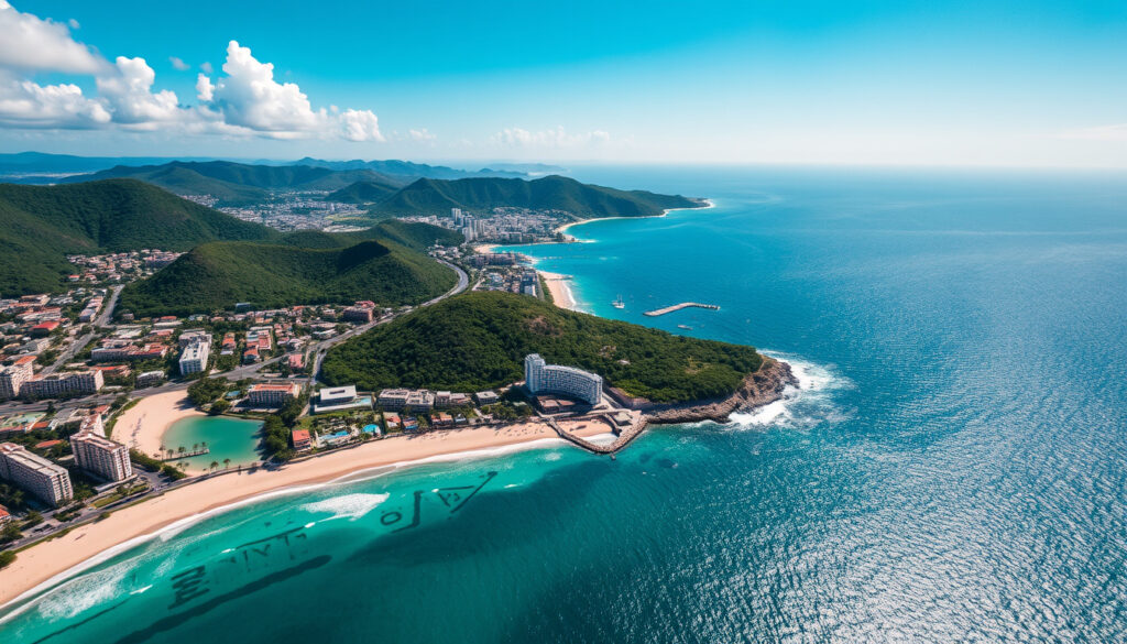
Beach culture dominates Puerto Rico’s tourism identity, but the character of those beaches varies dramatically by region. The north coast around San Juan features urban beaches with ready access to restaurants, hotels, and nightlife. The west coast draws surfers and those seeking quieter beach towns. The east coast near Fajardo and the Vieques/Culebra islands offer more secluded settings and excellent snorkeling.
- Condado – San Juan neighborhood with vibrant beach scene, upscale hotels, and active security presence
- Rincón – Northwest surf town known for sunsets, whale watching, and consistent waves
- Isla Verde – Resort beach area 10–15 minutes from San Juan airport, wide sandy shores
- Dorado – Ultra-luxury enclave with gated resorts and private beach clubs
- Fajardo – Marina hub with bioluminescent bay and ferry access to neighboring islands
Top attractions
Old San Juan stands as the cultural heart of the island. The Moon Travel Guides maps document this historic district, founded in 1521 by Spanish settlers. Two imposing fortresses—Castillo San Felipe del Morro and Castillo de San Cristóbal—anchor the walled city and offer panoramic views of San Juan Bay.
El Yunque Caribbean National Forest covers 28,000 acres on Puerto Rico’s east coast, making it the only tropical rainforest under U.S. National Forest Service management. The Moon Travel Guides geography notes position this preserve in the Sierra de Luquillo mountains, where trails wind through dense vegetation past waterfalls and scenic overlooks.
Bioluminescent bays rank among Puerto Rico’s most magical attractions. Three confirmed bioluminescent bays—Laguna Grande near Fajardo, La Parguera near Lajas, and Mosquito Bay on Vieques—glow bright blue-green when disturbed at night. The Swim Guide reports that Puerto Rico hosts some of the brightest bio-bays in the world, thanks to high concentrations of dinoflagellate plankton.
Are there any areas to avoid in Puerto Rico?
Most crime in Puerto Rico is gang- or drug-related and concentrated in specific neighborhoods that tourists rarely need to visit, according to Under 30 Experiences. Violent crime rarely affects tourists, and petty theft combined with late-night incidents represents the most common risks for visitors.
Safety in tourist areas
Major tourist zones maintain strong safety profiles through active community vigilance and private security presence. Christie’s Real Estate Puerto Rico identifies several neighborhoods as among the safest on the island:
- Condado – One of the safest neighborhoods, favored for its active community, security measures, and accessibility
- Ocean Park – Residential beach neighborhood quieter than Condado, popular with families
- Aguadilla – Luxury coastal destination on the west coast with family-friendly environment
- Dorado – Ultra-luxury enclave with gated resorts, golf, and private security
Old San Juan, Isla Verde, and popular beach towns like Rincón also report low incident rates for tourists. Under 30 Experiences confirms that solo travelers, including women, visit Puerto Rico safely every day.
Crime hotspots
Certain neighborhoods in San Juan—particularly some public housing areas and blocks near major highways—see elevated crime rates. These areas include parts of Santurce near the oceanfront and some inland blocks of metropolitan San Juan. Visitors should avoid wandering into unfamiliar residential blocks at night, especially after drinking establishments close.
The hurricane season runs from June 1 to November 30, and Christie’s Real Estate Puerto Rico notes that coastal areas have tsunami evacuation maps published by the PR Seismic Network. Rip currents pose low but present risks near inlets, groins, jetties, reefs, and piers, according to Swim Safe PR.
Petty theft and late-night incidents are the most common tourist risks. Stay aware in crowded areas, secure valuables in accommodations, and avoid unfamiliar neighborhoods after dark. The implication: common-sense precautions largely eliminate risk in tourist areas.
Upsides
- Violent crime rarely affects tourists in major areas
- Most crime is concentrated in known neighborhoods
- Safe neighborhoods like Condado and Aguadilla have active security
- U.S. emergency services and medical facilities available
- Tsunami and hurricane safety infrastructure exists
Downsides
- Certain San Juan neighborhoods should be avoided at night
- Petty theft occurs in tourist areas
- Drug-related crime affects specific communities
- Hurricane season runs 6 months each year
- Crime statistics by neighborhood lack current public data
What are the main cities on Puerto Rico map?
Major cities in Puerto Rico include San Juan, Ponce, Mayagüez, Bayamón, Caguas, and Carolina, according to Welcome to Puerto Rico. Each serves a distinct regional function and offers different experiences for visitors.
San Juan anchors the northeast coast as the capital and largest metropolitan area, hosting the airport, cruise ship port, and primary tourism infrastructure. The Moon Travel Guides geography confirms San Juan’s position on the northeast coast, making it the gateway for most visitors.
Ponce ranks as the island’s second-largest city outside metropolitan San Juan, according to Moon Travel Guides. This southern city was once a wealthy international port and major player in the sugar and coffee industries, leaving behind striking Art Deco architecture and the classic Parque de Bombas firehouse.
Mayagüez and San Germán anchor the west coast, both colonial cities with distinct character. Mayagüez serves as the western hub for commerce and hosts the university’s western campus. The Moon Travel Guides documentation notes these cities are key stops for travelers exploring the surf towns of Isabela, Rincón, and Aguadilla.
The pattern: population and commerce concentrate in the San Juan metropolitan area, while regional cities serve their surrounding areas with distinct cultural identities.
How to read a Puerto Rico road map?
A standard Puerto Rico road map follows U.S. highway conventions, with Interstate and national routes marked alongside PR-state-designated highways. The main highways ring the island, while secondary roads penetrate the interior mountains and connect smaller communities.
PR-1 runs along the north coast from San Juan westward through Arecibo and into the Mayagüez area. PR-2 serves as the primary west coast artery. PR-10 cuts across the interior, connecting San Juan to Ponce via a scenic mountain route. PR-3 runs along the east coast from San Juan through Fajardo.
- PR-1 and PR-2 – North and west coast highways, most traveled routes
- PR-22 – Tolls apply on this San Juan metro expressway
- PR-10 – Interior mountain route, slower but scenic
- PR-3 – East coast scenic route to Fajardo
Navigation apps like Google Maps and Waze work well for urban driving but may lag in remote areas like El Yunque or the Vieques interior. Offline maps are advisable when exploring beyond the main highways, particularly in the mountain regions.
The implication: a road map of Puerto Rico works like any U.S. state map, but expect mountain roads to slow travel times significantly below highway speed estimates.
Puerto Rico’s terrain creates natural zones that shape every visit. The north coast faces Atlantic weather patterns, the south stays drier, and the mountains receive the most rainfall—creating El Yunque’s rainforest conditions while surrounding areas stay drier.
— Moon Travel Guides (Geography Overview)
Tourists from the United States often express surprise that Puerto Rico uses U.S. dollars, operates under American law, and requires no passport for entry. This familiarity makes Puerto Rico an accessible Caribbean destination while still delivering a distinct cultural experience.
— Under 30 Experiences (Safety Guide)
For tourists planning a visit, the choice is relatively straightforward: major resort areas like Condado, Dorado, and Aguadilla offer luxury infrastructure and strong safety records, while adventurous travelers can explore lesser-known beaches and mountain towns using standard precautions. Puerto Rico rewards those who prepare with a good map and realistic expectations about what each region delivers.
Related reading: continents of the world · hurricane season
sanjuanpuertorico.com, ontheworldmap.com, travelmaps.com, discoverpuertorico.com
While the map outlines Puerto Rico’s cities and beaches, the latest 2025 safety facts for tourists provides essential insights into safer zones for 2025 visitors.
Frequently asked questions
What currency does Puerto Rico use?
Puerto Rico uses the U.S. dollar. As an unincorporated U.S. territory, Puerto Rico operates under American monetary policy. Credit cards are widely accepted in tourist areas, though cash remains common in smaller establishments and local markets.
What is rule 22 in Puerto Rico?
Section 22 of the U.S. Internal Revenue Code provides tax incentive programs for Puerto Rico residents and businesses operating on the island. These provisions offer certain federal tax advantages not available to U.S. state residents, making Puerto Rico an attractive location for remote workers and businesses seeking tax optimization.
What is the number one crime in Puerto Rico?
Drug-related crime represents the primary criminal concern in Puerto Rico. Violent crime rarely affects tourists, and most incidents are concentrated in specific neighborhoods involving gang activity. Petty theft and late-night incidents are the most common risks for visitors in tourist areas.
Why is Puerto Rico so famous?
Puerto Rico’s fame stems from its distinctive combination of American accessibility and Caribbean character. Old San Juan’s colonial fortresses, El Yunque rainforest, world-class surfing in Rincón, bioluminescent bays, and vibrant music scene all contribute to the island’s reputation. The unique status as a U.S. territory where U.S. citizens don’t need passports adds practical appeal.
What is the prettiest area in Puerto Rico?
Beauty depends on what you’re seeking. Old San Juan wins for colonial architecture and history. Rincón offers stunning sunset views over the Atlantic. Vieques and Culebra provide secluded beaches with crystal-clear water. El Yunque delivers lush rainforest scenery. The east coast near Fajardo combines coastal beauty with easy access to islands and bio-bays.
Is Puerto Rico safe right now?
Puerto Rico is generally safe for tourists, especially in major tourist areas like Old San Juan, Condado, Ocean Park, and popular beach towns. Violent crime rarely affects tourists. Most crime is gang- or drug-related and concentrated in specific neighborhoods that tourists rarely visit. Standard travel precautions apply, particularly regarding petty theft and late-night situations.
What are the best things to do in Puerto Rico?
Top activities include exploring Old San Juan’s forts and cobblestone streets, hiking El Yunque rainforest trails, surfing Rincón’s west coast breaks, snorkeling Vieques or Culebra’s reefs, kayaking a bioluminescent bay at night, golfing at resorts like Punta Borinquen in Aguadilla, and enjoying beaches ranging from urban Condado to remote Flamenco Beach on Culebra.
What does a Google map of Puerto Rico show?
A Google map of Puerto Rico displays the main island’s shape and coastline, major cities (San Juan, Ponce, Mayagüez, Caguas), primary highways (PR-1, PR-2, PR-22), tourist areas (Condado, Isla Verde, Rincón), and surrounding islands (Vieques, Culebra). Satellite view shows terrain variation from beaches to mountain ridges, particularly El Yunque’s distinct green mass on the east coast.
More related posts
 Hotel Jobs Near Me – Open Positions at Nearby Hotels
 Yeast Infection Symptoms: Signs, Causes & When to See a Doctor
 The Devil Wears Prada: True Story, Cast, Sequel & Facts
 How to Evolve Charcadet – Scarlet and Violet Guide
 Dandruff vs Dry Scalp – Key Differences, Causes and Treatments
 Emergency Garage Door Repair: Costs & Manual Operation
 Where Is Yosemite National Park? Location & Yellowstone Guide
 Happy Birthday Image Free: Be t Site , Copyright & Tip
